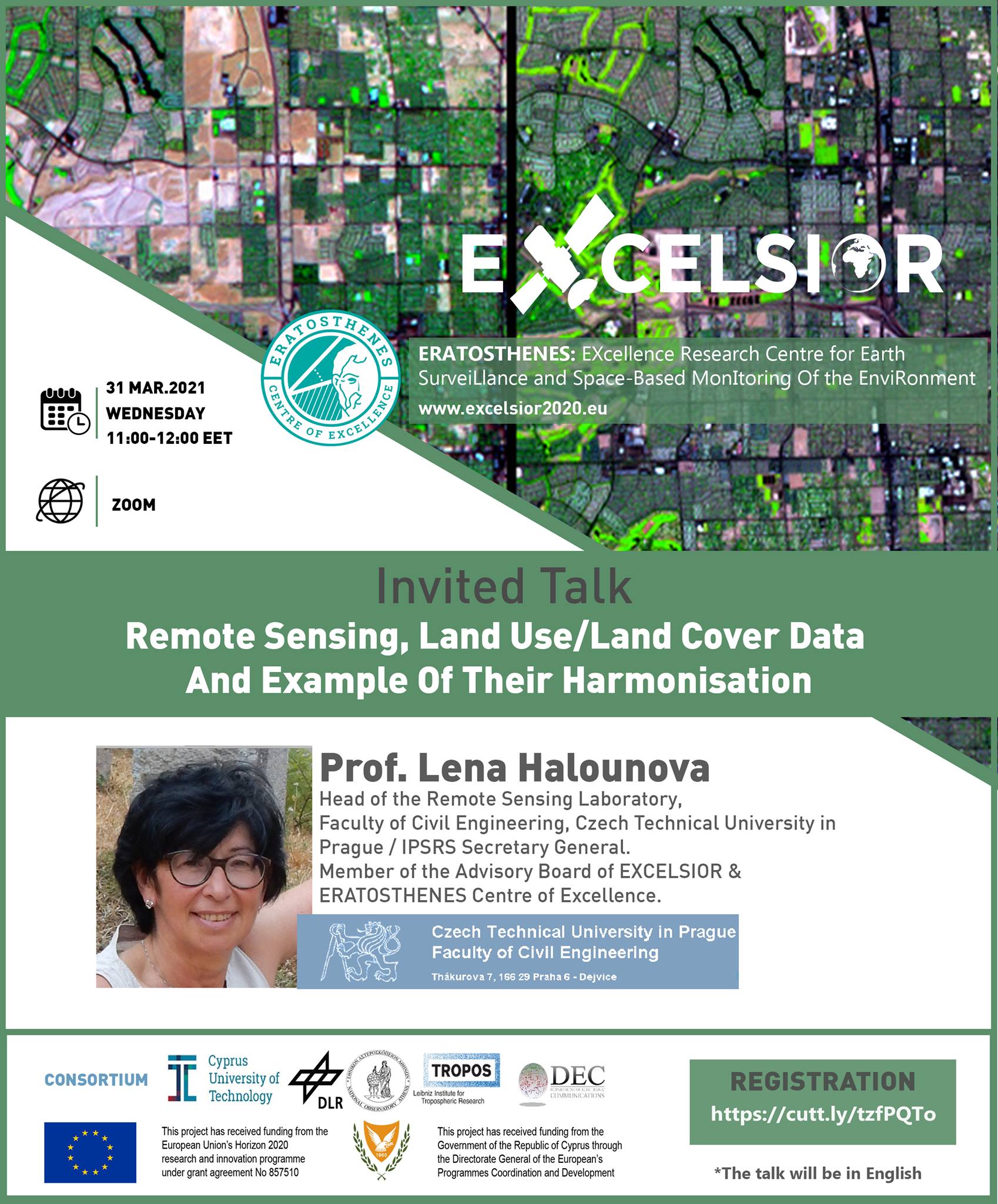
31 Μαρτίου 2021 | 11:00
Virtual Invited Talk: Remote Sensing, Land Use/Land Cover Data and Example of Their Harmonisation
The EXCELSIOR H2020 project and the ERATOSTHENES Centre of Excellence (ECoE) of the Cyprus University of Technology organize a virtual invited talk by Prof. Lena Halounova.
*Free attendance
** The talk will be held in English.
**Registration required: https://cutt.ly/tzfPQTo
(The invitation link will be sent to the registered participants per e-mail)
Speaker: Prof. Lena Halounova
Facebook Event: https://fb.me/e/1A6dLr0GW
Since graduation from the Czech Technical University in Prague (Faculty of Civil Engineering), Lena Halounová remained within its walls during her Ph.D. at the Department of Hydrotechnics, and then moved to the Remote Sensing Laboratory of the Department of Mapping and Cartography, which she is heading today. In her research, Lena pays special attention to issues of using optical and SAR remote sensing data and GIS applications for solving problems of water engineering, erosion, reclamations, landslides, land subsidence, detection of vegetation in urban areas, change detection in urban areas, etc. Numerous works and publications of Lena Halounová as well as her lectures in Prague universities are dedicated to these topics.
Along with being appointed the Chairperson of the Czech Society for Photogrammetry and Remote Sensing in 2004, Lena represented the Czech Republic, the ISPRS ordinary member, where she held the position of the Chairperson of the Financial Commission from 2008 to 2012. During the XXII ISPRS Congress in Melbourne, Lena was elected the Director of the 2016 ISPRS Congress, which was held in Prague, July 12-19, 2016 where she was elected ISPRS Secretary General for the next ISPRS inter-congresses periods.
Remote Sensing, Land Use/Land Cover Data and Example of Their Harmonisation
31 Μαρτίου 2021 | 11:00
Virtual Invited Talk: Remote Sensing, Land Use/Land Cover Data and Example of Their Harmonisation
The EXCELSIOR H2020 project and the ERATOSTHENES Centre of Excellence (ECoE) of the Cyprus University of Technology organize a virtual invited talk by Prof. Lena Halounova.
*Free attendance
** The talk will be held in English.
**Registration required: https://cutt.ly/tzfPQTo
(The invitation link will be sent to the registered participants per e-mail)
Speaker: Prof. Lena Halounova
Facebook Event: https://fb.me/e/1A6dLr0GW
Since graduation from the Czech Technical University in Prague (Faculty of Civil Engineering), Lena Halounová remained within its walls during her Ph.D. at the Department of Hydrotechnics, and then moved to the Remote Sensing Laboratory of the Department of Mapping and Cartography, which she is heading today. In her research, Lena pays special attention to issues of using optical and SAR remote sensing data and GIS applications for solving problems of water engineering, erosion, reclamations, landslides, land subsidence, detection of vegetation in urban areas, change detection in urban areas, etc. Numerous works and publications of Lena Halounová as well as her lectures in Prague universities are dedicated to these topics.
Along with being appointed the Chairperson of the Czech Society for Photogrammetry and Remote Sensing in 2004, Lena represented the Czech Republic, the ISPRS ordinary member, where she held the position of the Chairperson of the Financial Commission from 2008 to 2012. During the XXII ISPRS Congress in Melbourne, Lena was elected the Director of the 2016 ISPRS Congress, which was held in Prague, July 12-19, 2016 where she was elected ISPRS Secretary General for the next ISPRS inter-congresses periods.